Survey 123

ArcGIS Survey123 is a powerful tool developed by Esri for creating, sharing, and analyzing smart surveys in a GIS (Geographic Information Systems) environment.
- It allows users to design forms for data collection using a simple drag-and-drop interface and deploy them to field workers or respondents via web or mobile devices.
- Survey123 integrates seamlessly with the ArcGIS platform, enabling users to leverage spatial data and analysis capabilities in their survey workflows.
Key Features:

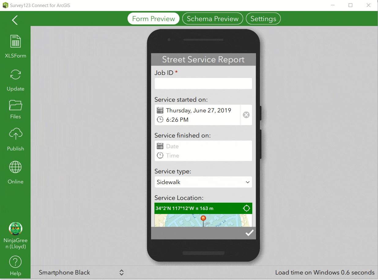
Form DesignerSurvey123provides an intuitive formdesigner interface, allowing users to create custom survey forms without any coding knowledge.- Users can add various question types, including
multiple-choice,text entry,date picker, and more, and configurevalidation rulesandskip logicto ensure data accuracy.
Mobile Data Collection- Surveys created with Survey123 can be deployed to mobile devices (
iOS,Android,Windows) using theSurvey123field app. - Field workers can collect data offline and synchronize it with the central database when connectivity is available, making it ideal for remote or disconnected environments.
- Surveys created with Survey123 can be deployed to mobile devices (
Integration with ArcGIS PlatformSurvey123seamlessly integrates with the ArcGIS platform, allowing users to leverage spatial data and analysis capabilities in their surveys.- Users can attach
geotagged photos, recordGPS coordinates, or capture spatial data directly within the survey form.
Real-time MonitoringSurvey123provides real-time monitoring anddashboardcapabilities, allowing users to track survey responses as they are submitted.- Users can visualize survey data on interactive
maps,charts, andgraphs, enabling quick insights and analysis.
Integration with Other SystemsSurvey123integrates with other systems and applications viaREST APIs, allowing users to automate data exchange, integrate with third-party services, or extend the functionality ofSurvey123.
Creating and Designing Survey
- Access Survey123 through ArcGIS platform.
- Create a new Survey
- You can create a survey from scratch, or using a template, or you already had one established using Survey 123 desktop version. In this example, we start from scratch

- You can create a survey from scratch, or using a template, or you already had one established using Survey 123 desktop version. In this example, we start from scratch
- Explore the element provided in
Survey 123 - Final demo
- ArcGIS Online only allow basic design, a better way to design a complicate survey is using
Survey 123 Connector(desktop version)
- ArcGIS Online only allow basic design, a better way to design a complicate survey is using
Survey from xls
XLS Forms is a powerful specification for designing forms for data collection, and it's the backbone of creating surveys in ArcGIS Survey123.
XLS Forms allow users to design complex surveys using a simple Excel-based format, making it easy to create structured data collection instruments without the need for programming skills.
XLS Form Structure
The XLS Form structure consists of various columns that define different aspects of the survey. Some of the key columns include:
`
type: Specifies the type of question (e.g.,text,integer,select_one,select_multiple).name: A unique identifier for each question.label: The text displayed to the user for each question.(Field Name)constraint: Defines validation rules for the question (e.g.,range,pattern).relevant: Specifies conditions under which the question is relevant (e.g.,skip logic).

choice list: Specifies predefined choices for select-type questions (if using the Choices sheet)


Incorporate Survey 123 with ArcGIS Collector
- Reference
- Both the
CollectorandSurvey123applications must be installed on user's device- The specific survey form must be downloaded on the
Survey123app - The end users must have access to the
layers,Collector map, etc. - Every field in the Survey123 form must exist in the
related table - The hosted
feature layer&related tablemust be related based onGlobal IDfields
- The specific survey form must be downloaded on the
Difference between these two tools

Workflow
In
settingsfrom therelated table, check thesubmission_url, it should be a feature layer url
In ArcGIS Desktop, run the
Create Relationship ClassGP tool to relate thefeature layerandrelated tablerelated tableare records submitted bySurvey 123- The relationship class must be built using Global ID's


Once the relationship class is built, publish the feature class to
ArcGIS Onlineas a hosted feature layerPublish the Survey form from
Survey123 Connectto ArcGIS OnlineConfigure survey settings to open survey in mobile app
- Remember to save survey setting
- Copy the link for distributing

Create a web map for use in
ArcGIS Collectorapplication- To enable a web map for Collector, at least 1 layer must be editable and have a popup enabled
Configure the web map with the inspections
feature layer&related table, as well as any other desired data layers- configure the pop-up in the web map
- Choose to display
A custom attribute display, selectconfigure - Insert hyperlink for access to survey form
- Choose to display

- configure the pop-up in the web map